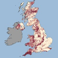
The UK Health Security Agency (UKHSA) and the British Geological Survey (BGS) have published a new radon map. The map, the first in over ten years, has been updated for England, Wales and Scotland; the map for Northern Ireland was last updated in 2015 and remains unchanged. The new map is available to view and identifies the percentage of homes expected to exceed the 200Bqm-3 radon action level for the home. The Ionising Radiations Regulations…
23rd Feb 2023